Topo programs for the computer.

Thanks guys. I had seen the spatialminds site before but never knew they sold the GPS antennas there, just thought they sold software. I checked into that usb puck they have there and after seeing a few good things about that GlobalSat 353 on expo and other forums, I ordered one. I'll post up what I find when it arrives.
 
Well I am going to need something for my laptop to aid in mapping and navigation and need to make a decision soon.

I am going to test out topofusion and was thinking about DeLorme Topo 9.0. I like the fact the topofusion does not charge a fee for information that is already in the public domain. I have plenty imagery and topo for use in GIS applications and would hate to pay a fee to DeLorme to download them again for use in Topo.

To cut off my rant, my question is how do you guys deal with needing to download data within the application? I would hate to be out on the trail only to realize I forgot to download a tile or two.

Josh
 
I have entire states downloaded with both aerial imagery, 24k topo's, noaa charts and some other stuff. I know some is public domain but for the download subscription price it eliminates the headache of getting it to zero right. If you have your own stuff should use XMap to get it to work.

Yes its a lot of space, but I have it, and its not going anywhere now. It only takes a little bit of foresight to know what I'll need.

Yeah but I would rather not get into the XMap kind of cash. As long as I can download by county and/or by state with the annual membership then I would be happy.

I'll call their customer service for more info, thanks.

Josh
 
The download segments for topo 8.0 are pretty small chunks for all data levels (except Noaa charts, you get the whole chart), maybe like 80-100 acres or bigger?
 
The download segments for topo 8.0 are pretty small chunks for all data levels (except Noaa charts, you get the whole chart), maybe like 80-100 acres or bigger?

Yeah, thanks for the info. I am in Maine and saw the DeLorme headquarters off the freeway so I stopped in and played with Topo 9.

I am not sure what they where running it on but it was pretty slow in loading maps. I wish they would let you get more data at a time. Due to the business model, of their map data, and the software's performance I am leaning toward topofusion and just using my images in mapwindow if I run into a situation where I forgot to download a map.

It was nice to finally get to use Topo software an see it first hand.

Josh
 
Well I use the PN-40, and not my laptop, for wheeling it's what suits me. I was using topo 7.0 w/o a PN device and an external antenna on my laptop first, but after cleaning out a bunch of dust/dirt from it, I went with the pn-40 which came with topo 8.0. That's my reasoning for running it, if you're planning on doing something different its understandable.
 
My opinion (not that it's worth anything):

Netbook:
After a year of being taught ESRI ArcGIS, I still feel inadequate.
I don't know about other programs, but based on the ESRI software, my new laptop did great. I can't see a netbook being able to run some of the more difficult processes.

As for MAKING SURE I have all of the needed data. EVERYTHING I think I might or might not need, is downloaded on a portable back-up drive. Picked up my back-up drive at the recommendation of the GIS Professor. Learned to frequently back-up and save in two (or more) locations, after my first Laptop's drive fried. Luckily the new laptop arrived the day before.

This definitely didn't answer the primary questions here, but I had to add my .02.

And since I don't show this stuff off. I might as well. Has not been updated since the last few weeks of class:
http://sites.google.com/site/jasongouldgis/home
 
After having a GIS major, ArcGis is not the best option to run for trail use. Sure, make yourself some maps but clunky to use "in action". Back-up's are a good idea though! My professors always wanted us to have a copy on our comp's, a back up drive, and the school's system, as well as use the old adage "Save early, save often."
 
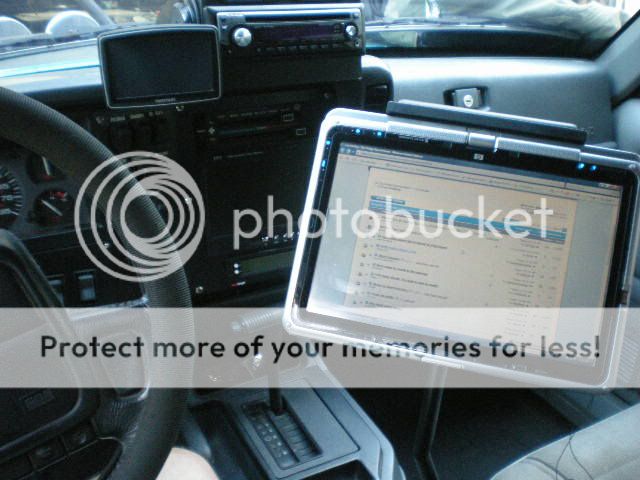
Built a laptop mount after last weekends trip making me realize how bad my GPS was.
I still need to buy delorme topo, but i got Streets and Trips 2010 on it and about 3/4 my mp3s...

4924070249_9e3fc950f7_b.jpg

4924664410_3c57d9021c_b.jpg

4924070573_c3a751bd72_o.jpg

4924664640_5ede8b1259_o.jpg
 
Bringing this back up to the top, thinking about trying the Overland Navigator for my tablet set-up, anyone on here used it?

I am really looking for something to utilize my touchscreen, and the ON seems to fit that bill with the big buttons, and streamlined program design.

Just looking for some feedback from you guys... have read a lot about it on EXPO, but that site can sometimes be skewed...

Using it on my HP Pavilion TX1000, with a Globalsat 353 puck.

Here is a pretty picture too... :D

DSCN1485.jpg


DSCN1412.jpg


They gave a complete mapping set out at SierraFest last summer, wish I would have won it I really wanted to try it out.

I have been using Topo Fusion and like it quite a bit. They have a free download to try it out.

What laptop bracket are you running, I need on of those too...
 
I have used TopoFusion for a while, and its a good program. I just want something a little more touchscreen friendly, and simpler to use. mostly while running down forest roads, its kind of hard to deal with Topofusion since you have to use the keyboard and mouse so much.

The complete mapping set would have been tits for sure... I think I may go ahead and try it out, it certainly seems like what I am looking for.

I made the laptop mount myself. There is a build thread for it somewhere on here...

~ Stump
 
I made the laptop mount myself. There is a build thread for it somewhere on here...

~ Stump

Come to think of it I think I read that thread a while ago, I'll look it up again. You did a damn fine job on yours.

I agree that Topo Fusion does become slightly cumbersome when trying to use the keyboard and stupid touch pad that is always covered in a thick layer of dust rendering it almost useless.

Let me know you impression of Overland Nav. I am curious what they use for a base map. Sub 1 meter imagery or the ability to import my own basemap is key for me.

Good luck,

Josh
 
Been looking at Delorme TOPO 9.0. Anybody have any first hand experience?
 
I am getting ready to purchase a new GPS with Delorme Topo. I have an older version and still use it even though it is outdated. ARC GIS is fantastic although not real user friendly and definitely expensive for the full version. We use MapTech with the search and rescue group that I belong to. It is a little more expensive but very well updated and accurate.
I would like a laptop in the XJ but I don't want to give up the real estate.
 
If you've got an iPhone or iPod touch, you might want to check out Motion X GPS.

Works well enough for me.
 
I am designing a laptop mount for my rig and have a couple of year old laptop I am going to install. The Delorme TOPO 9.0 looked like a good option. I have an old copy of National Geographic TOPO with maps for Colorado, but have fought with trying to get maps for other states to work together.

I played with Spatial Minds for a few minutes, but is seemed a bit clunky.
 
Been looking at Delorme TOPO 9.0. Anybody have any first hand experience?

I was in Maine this past summer and stopped in the Delorme map store to give it a test drive. I was not terribly impressed with it, although I only played around with I for about half an hour. My intent was to buy it right then and there.

It not the simplest thing to navigate and I am not a fan of the pay per tile / region plan, especially when the data is in the public domain to begin with.

There are far cheaper and simpler programs available. I love topo fusion and the fact that the maps are FREE downloads. Thats a big deal for me.

Josh
 
I snagged a brand new in the box for $50 so I am going to give it a whirl. I may work on converting some of the map data for use on it.
 
Back
Top