RockTracXJ
NAXJA Forum User
- Location
- Colorado Springs
At the beginning of last year I was able to get my hands on an iPad Air cellular, with the cellular being key because it has the GPS chipset built in (unlike the wifi only models) so it can be used with offline maps for navigating in the backcountry. I got some map apps on it, downloaded some maps and offroad I went. The first wheeling trip I took with the iPad was great, I think this was one of the best/most enjoyable ‘mods’ I had made to my Jeep in a long time. Compared to having to monkey around with paper maps and gazetteers, having everything right at my fingertips all the time and knowing EXACTLY where I was all the time was fantastic. I also got a Bluetooth deck and streamed music from the iPad.
Here’s some of what I used/learned this past year:
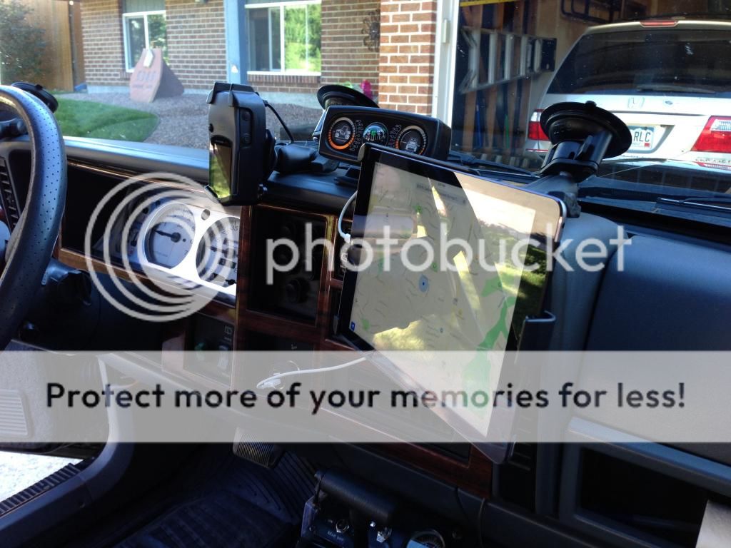
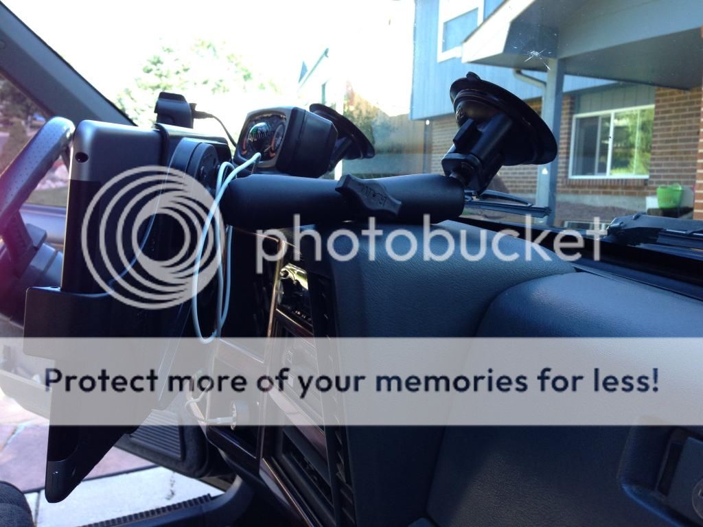
Ram-Mount for the actual mounting of the iPad. Ram-mounts are great and this one worked quite well. I experimented with some other options, but this turned out the best. The longer double socket arm works well and allows me to rest it on the dash to keep down on vibrations. Their ipad specific cradle worked great even in portrait.
As for the apps, here’s what I’ve tried and my thoughts on each.
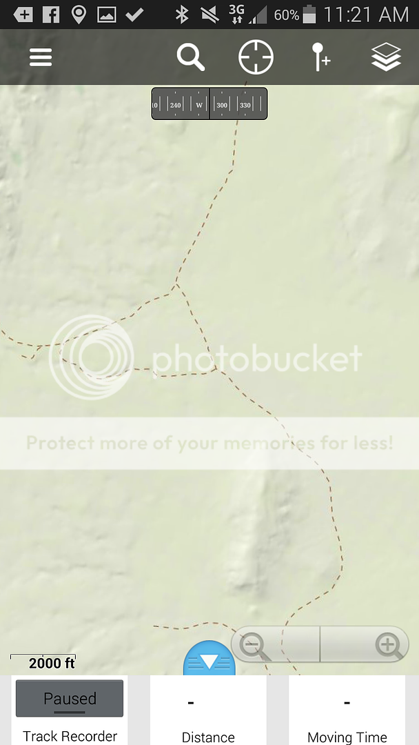
Motion-X GPS – This is my go-to map app. The topo and road maps are free for download through OpenCycle maps and you can record waypoints and tracks. Fairly easy to get the maps downloaded for use (a bit slow though, and fairly easy to use up space if you don’t properly set the zoom level) If you’re connected to data they also have Bing, Apple, and Google maps available. GPX files can be imported fairly easily.
Trimble Outdoors MyTopo Maps – Great Topo maps, they show a lot of trails and give you a better idea of terrain than other maps. It has a cool slider to go between map view and aerial view. Waypoints can be marked, but tracks can’t be recorded. For a $30/year membership, unlimited maps can be downloaded. They’re a bit more work to get on the iPad, but work great once you do. Small gripe – using this app won’t keep the ipad from locking.
Galileo – Basic app is free, pro version is $4 (pro version is needed for much of the good functionality). I don’t have as much time in using this one, but it seems to have some good potential. Free USGS topo maps (‘The National Map’) can be downloaded and used and they look pretty sharp, but don’t show as many trails. Tracks can be recorded. A variety of online maps are available. Getting the free USGS topo maps on the iPad is a bit more work.
More info here: http://www.usgs.gov/core_science_systems/access/summer_2013/article-1.html
PDF Maps – This is another one I haven’t spent as much time using. I originally got this app because you can use it to download and view all of the Forest Service MVUMs for free. It seems to have some good potential, they have a lot of maps (including free) available in their map store. Downloading maps is easy. All of the maps look like paper versions in electronic form. Tracks can be recorded.
On-road apps:
GPS CoPilot – Wanted to use this for on-road driving and navigation. Worked OK. Had some issues with locking up. Wasn’t that impressed.
MotionX GPS Drive – After being unimpressed with GPS CoPilot, I’m looking forward to trying this app in the future for on-road driving and navigation.
Here’s some of what I used/learned this past year:
Ram-Mount for the actual mounting of the iPad. Ram-mounts are great and this one worked quite well. I experimented with some other options, but this turned out the best. The longer double socket arm works well and allows me to rest it on the dash to keep down on vibrations. Their ipad specific cradle worked great even in portrait.


As for the apps, here’s what I’ve tried and my thoughts on each.
Motion-X GPS – This is my go-to map app. The topo and road maps are free for download through OpenCycle maps and you can record waypoints and tracks. Fairly easy to get the maps downloaded for use (a bit slow though, and fairly easy to use up space if you don’t properly set the zoom level) If you’re connected to data they also have Bing, Apple, and Google maps available. GPX files can be imported fairly easily.
Trimble Outdoors MyTopo Maps – Great Topo maps, they show a lot of trails and give you a better idea of terrain than other maps. It has a cool slider to go between map view and aerial view. Waypoints can be marked, but tracks can’t be recorded. For a $30/year membership, unlimited maps can be downloaded. They’re a bit more work to get on the iPad, but work great once you do. Small gripe – using this app won’t keep the ipad from locking.
Galileo – Basic app is free, pro version is $4 (pro version is needed for much of the good functionality). I don’t have as much time in using this one, but it seems to have some good potential. Free USGS topo maps (‘The National Map’) can be downloaded and used and they look pretty sharp, but don’t show as many trails. Tracks can be recorded. A variety of online maps are available. Getting the free USGS topo maps on the iPad is a bit more work.
More info here: http://www.usgs.gov/core_science_systems/access/summer_2013/article-1.html
PDF Maps – This is another one I haven’t spent as much time using. I originally got this app because you can use it to download and view all of the Forest Service MVUMs for free. It seems to have some good potential, they have a lot of maps (including free) available in their map store. Downloading maps is easy. All of the maps look like paper versions in electronic form. Tracks can be recorded.
On-road apps:
GPS CoPilot – Wanted to use this for on-road driving and navigation. Worked OK. Had some issues with locking up. Wasn’t that impressed.
MotionX GPS Drive – After being unimpressed with GPS CoPilot, I’m looking forward to trying this app in the future for on-road driving and navigation.