drifto77
NAXJA Forum User
- Location
- Sherman,TX.
Well..... I got to go to Colorado agian this year after all!!!!
I thought the price of gas was gonna keep me from going but Sometimes you just have to say "The #%** with it".
The wife and I left Texas at 1:30am on 30 Oct. after she got off work
and returned a week later on the following Thursday. The plan was for her to sleep for a few hrs and then switch driving, I only had 1 1/2 hrs sleep before we left. Well... it did not work like that. I drove the entire 15 1/2 hrs to Montrose. (just north of Ouray)
We stayed with a friend that just moved up there, so that helped cut the cost so we had a little more for gas.
I had a BLAST!!! how can you not in Colorado?
Here is a list of the trails we did this year............
Day 1 of trails........
Part of the way up Brown Mt. , Corkscrew Pass, Hurricane Pass, California Gulch, up to the top of Engineer Pass then down to Silverton.
Day 2 of trails...........
Camped out just off of Black Bear. It got down to near freezing and rained almost all night. The wife froze. :enet-toothy:
The next day was BEAUTIFUL!!
Ran Black Bear,
Then went over Imogene Pass. BOY was it crowded at the top!!!!
There were about 30 Jeeps up there when we got to the top!
Day 3 of trails.........
Went as far up as you can go into Governors Basin. This trail is narrower than Black Bear in a lot of spots with VERY FEW places to pass. Good thing we were one of only 3 on the trail that day.
Day 4 of trails.......
Was on the way home. Owl Creek Pass and Silver Jack Reservoir.
This is an EASY dirt road and can be done in a car but was just like the rest of the trails..... VERY BEAUTIFUL!!!
Wish I was still there. Sad
The Aspins were "just starting" to give a hint of the colors to come.
Should be starting a color change in about 2 or 3 more weeks.
Got lucky agian this year, NO carnage!!!! Except when the C.B. fell from where it was mounted and hit my feet.
Anyway..... like I said, I HAD A BLAST!!!! Anyone that has not been to South West Colorado needs to go sometime.
Its worth the trip.
Here are the pics............
3 of my favorites.........
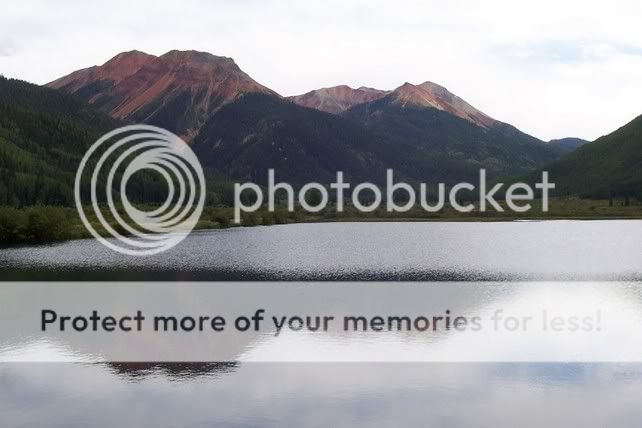
Reflections of Red Mountian

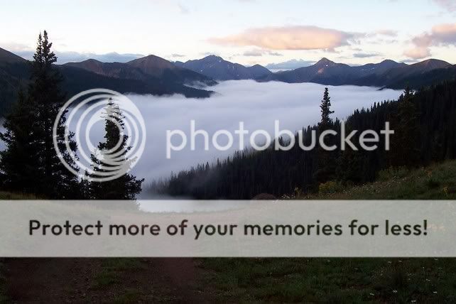
First light on Black Bear
same valley, different spot without the clouds.......

Here they are.
ENJOY!!!!

http://photobucket.com/albums/a140/whitecherokee/
(still have a few to add)
I thought the price of gas was gonna keep me from going but Sometimes you just have to say "The #%** with it".
The wife and I left Texas at 1:30am on 30 Oct. after she got off work
and returned a week later on the following Thursday. The plan was for her to sleep for a few hrs and then switch driving, I only had 1 1/2 hrs sleep before we left. Well... it did not work like that. I drove the entire 15 1/2 hrs to Montrose. (just north of Ouray)
We stayed with a friend that just moved up there, so that helped cut the cost so we had a little more for gas.
I had a BLAST!!! how can you not in Colorado?
Here is a list of the trails we did this year............
Day 1 of trails........
Part of the way up Brown Mt. , Corkscrew Pass, Hurricane Pass, California Gulch, up to the top of Engineer Pass then down to Silverton.
Day 2 of trails...........
Camped out just off of Black Bear. It got down to near freezing and rained almost all night. The wife froze. :enet-toothy:
The next day was BEAUTIFUL!!
Ran Black Bear,
Then went over Imogene Pass. BOY was it crowded at the top!!!!
There were about 30 Jeeps up there when we got to the top!
Day 3 of trails.........
Went as far up as you can go into Governors Basin. This trail is narrower than Black Bear in a lot of spots with VERY FEW places to pass. Good thing we were one of only 3 on the trail that day.
Day 4 of trails.......
Was on the way home. Owl Creek Pass and Silver Jack Reservoir.
This is an EASY dirt road and can be done in a car but was just like the rest of the trails..... VERY BEAUTIFUL!!!
Wish I was still there. Sad
The Aspins were "just starting" to give a hint of the colors to come.
Should be starting a color change in about 2 or 3 more weeks.
Got lucky agian this year, NO carnage!!!! Except when the C.B. fell from where it was mounted and hit my feet.
Anyway..... like I said, I HAD A BLAST!!!! Anyone that has not been to South West Colorado needs to go sometime.
Its worth the trip.
Here are the pics............
3 of my favorites.........
Reflections of Red Mountian
First light on Black Bear
same valley, different spot without the clouds.......
Here they are.
ENJOY!!!!
http://photobucket.com/albums/a140/whitecherokee/
(still have a few to add)

 the next week. I didn't have too much trouble getting a bunch of flatlanders to listen to instructions after I told them about the deaths the previous week.


")
")