• Welcome to the new NAXJA Forum! If your password does not work, please use "Forgot your password?" link on the log-in page. Please feel free to reach out to [email protected] if we can provide any assistance.

Moab

drifto77

NAXJA Forum User
Location
Sherman,TX.
Iam Going to Colorado (montrose) on 20 May 06 to see a buddy get married.
I was planning to do some wheeling in the San Juans agian this year but dont think a lot will be open yet due to snow.
I really wanted to do "The Bear" agian and The Alpnie Loop to Lake City and back.
frown.gif

So... i need a back-up plan.

MOAB.

Its only... what... just over 3 hrs from there.
What I need, since I have never been to Moab is some info.

TRAILS
What trails would be doable in my XJ?
Its got a 2" BB and Iam gonna throw the 30's on it. Other than that, its all stock.
For trails, I like the senic ones and shelf roads are not a problem.
My buddy and his future wife will be going too. He has also never been there.
He has a TJ (poor guy) thats stock and 2 inch BB.
Guess he DOES have something over mine though... he can go topless.
(i would post some topless pics here, but i dont have access to the den YET)

CAMPING
where?
I dont like crowds and prfere(sp?) wilderness camping.

WEATHER
whats it like there this time of year?
temp and rain?

MAPS
how about some i can print out or where can i get some CHEEP?

Since Iam taking the DD i would like to stay away from any body damage and all that.
Texas is too far away to drive home with glass missing, crab walking down the road and all that stuff.

YES.... iam also searching this site and all over the web.
Just wanna hear from people that have 1st hand knowledge of the area.
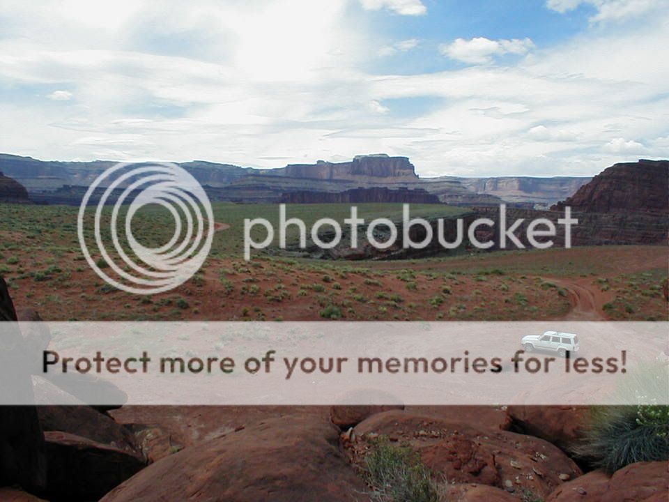
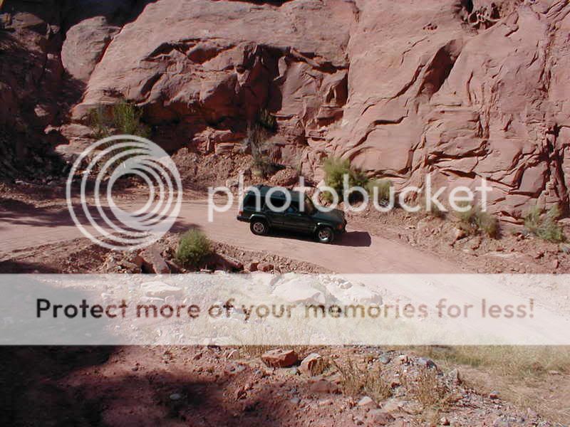
Stuff like this is what Iam looking for....
065510.JPG

(bottom pic stolen from "XJ Jeepin Girl", hope ya dont mind
icon10.gif
)
CanyonLandsNP001.jpg


ANY info would be VERY helpfull.
Like I said.... aint never been there.
Thanks
smokin.gif
 
The first thing I would suggest to you is to buy this book.
http://www.4x4books.com/mub.htm

He pretty much has every trail that is popular and describes them really well as far as difficulty and terrain.

As far as maps go...When you get to town stop in at the map store. I can't remember the address but it is on a side street just east of main right across the street from the Visitor Center. They are very good at getting you what you need.

As far as trails go...One thing about being stock or close to it...the easier trails a lot of times are more scenic.

Two I would recomend for beauty are Shaffer trail (which is where the second pic in your post was taken) and Hurrah Pass. Both are in that book.

If you want to challenge yourself and your jeeps ability a little bit you could also tackle Fins and Things. It is easily doable in a stock or close to stock jeep and you shouldn't have to worry about body damage. There are some very steep slickrock domes to play on that will blow your mind at how capable your jeep really is.
Here are a couple of shots of fins and things
34677%3C%3B6%3A%7Ffp58%3Dot%3E2334%3D%3C8%3A%3D324%3DXROQDF%3E2323845844%3A%3A7ot1lsi


34677%3C%3B6%3A%7Ffp4%3Enu%3D3243%3E%3B99%3E233%3EWSNRCG%3D3232936756%3C27nu0mrj


34677%3C%3B6%3A%7Ffp64%3Dot%3E2334%3D%3C8%3A%3D324%3DXROQDF%3E2323845847949ot1lsi


Another one you can tackle which is a little more challenging but body damage shouldn't be an issue is Seven Mile Rim.
A couple from that trail too.
34677%3C%3B88%7Ffp47%3Dot%3E2334%3D%3C8%3A%3D324%3DXROQDF%3E23237%3A5%3B99%3B%3A3ot1lsi


34677%3C%3B88%7Ffp47%3Dot%3E2334%3D%3C8%3A%3D324%3DXROQDF%3E23237%3A5%3B%3A39%3C7ot1lsi


34677%3C%3B88%7Ffp4%3Enu%3D3243%3E%3B99%3E233%3EWSNRCG%3D3232896%3A%3B24%3A7nu0mrj


Thats a stock Durango with me so you shouldn't have a problem.
34677%3C%3B88%7Ffp4%3Enu%3D3243%3E%3B99%3E233%3EWSNRCG%3D3232896%3A%3B47%3A7nu0mrj


If you have a GPS and know how to use it that book will help you even more because it has all the cords for all the trails.

Hope this helps some.
 
hail.gif

Thanks.
I had to copy and paste the link for some reason.
Dont know why I did not think about the book.
dope.gif

Charles Wells ROCKS!!!!
I have his book for Colorado. (vol#1) LOVE IT!!!!
All the trails that I have run in the San Juans that are in his book the discriptions are DEAD ON.
Its a FANTASTIC book!
Trails Illustrated by National Geographic puts out some sweet maps also.
I have #141 / Telluride,Silverton,Ouray & Lake City... Its AWESOME!!!!

OH.. BTW...
no GPS.
I'd never be able to figure out how to use it anyway.
My brain is stuck in the stone age, i do good just to make this damn computer work.
Screen_of_Death.gif

BUT... give me a map and a compass, thats a different story.
Iam an old school backpacker. Least I was in my younger years.
laughing.gif
 
drifto77 said:
BUT... give me a map and a compass, thats a different story.
Iam an old school backpacker. Least I was in my younger years.
If you can use a map and compass go to that map store.

I can not find the address but it is about two stores east of Main St on Center st. Its right across from the Visitors Center. They have tons and tons of maps set up specifically for off-roaders.
 
klondikes bluff is very reasonable.
gemini bridges
fins is always good

i always camp at the Moab Campground just out of town. Not scenic, has RV parking and tent camping. Nice place and fairly cheap.
 
rock rash said:
klondikes bluff is very reasonable.
gemini bridges
fins is always good

i always camp at the Moab Campground just out of town. Not scenic, has RV parking and tent camping. Nice place and fairly cheap.
Ohh...glad you brought that up....Yes. Gemini Bridges is another must do.

I think he was looking for wilderness camping though. If so remember this...
If you are close to the river you need to either have a portable toilet or be in a campground that has one.

I have camped many times on the road that heads out to Pritchett Arch. Nice camping areas around there. Just remember...close to water...bring a toilet.
 
here is part of the front of klondike bluffs
Picture020.jpg


Here is the back side...:D
Picture023.jpg


Here is Gemini Bridges
Picture041.jpg


And part of fins
Picture069.jpg
 
Hey! Thanks for stealing my pic! Haha, jk. I love that pic. Anyway... some answers for yah since I was just there:

The weather right now is windy. It gets up to 65 - 75 and is nice, but the wind makes it cold. Go early with whatever you are doing. If you are not familiar with desert weather, it rains usualy in the afternoon.

As for camping, I have yet to do that in Moab (La Quinta Inn all the way, baby), but I've heard that camping in Dead Horse State Park is really good. Most the campgrounds I saw looked over crowded and stuff, at least in town.

As people already said, Klondike Bluffs is great! It's my favorite trail to bike and four wheel. Never done Gemini Bridges, but everyone talks about that one too. ^^

I would not reccomend getting any maps off line really, cuz when I did that, I always got lost. Anyway, my friend has a great book.. of course I can't remember the name of it.. It's like Four wheeling trails in Moab, or something like that. But, it's all over the place in the many book shops of Moab (seriously, they have like 5 book stores, why?)

Anyway... hope some of that info helped. Any more questions, just ask. And good luck!
 
oh geez, an airbourne doorless xj! what kind of carnage was there? did it snap in half like a dried twig? did it fold like a soft-taco? i'm sure you must be insane for comprimising the structure of a jeep by removing the doors, and just plain mad to jump with them off. hahaha just kidding. sweet pics :sunshine:
 
muddygp said:
oh geez, an airbourne doorless xj! what kind of carnage was there? did it snap in half like a dried twig? did it fold like a soft-taco? i'm sure you must be insane for comprimising the structure of a jeep by removing the doors, and just plain mad to jump with them off. hahaha just kidding. sweet pics :sunshine:
kinda turned out like the pic of Rev Den's ren one. :D


actually bent the front axle housing. and needed to replace a ball joint or two.l

not going to be doing it this year in my new rig
 
haha sounds like fun...:repair:
truss up the old one and do it again ;-) good call on not doing it with the new one. one would think it can't be good for it, esp with oversized tires and all. . .an so i'm not a total hijacker, anyone know if there's good wheelin possible in telluride in mid june? probably around the 20th i'm planning a trip to co with the jeep and i need to figure out where i can wheel and not have to worry about passes snowed in and stuff.
 
I have camped on BLM land along the river off of 128. There are a couple of nice campgrounds with pit toilets and it is cheap. A lot of the spots have shade as well. It is still pretty close to town too.
 
For a stock XJ try Chicken Corners,

P4280030.jpg


Camping is located along the way and it is an easy trail. Very scenic. Just looking at that pic makes me want to be there. Just 3 weeks to go.
 
Ryan,
That's some ugly legs on that guy!
UglyGuy.jpg


Here's my stock XJ at the 25th anniversary.
On Pucker Pass (Schaffer Road)
PuckerpassTom.jpg


And Mary driving down Long Canyon
MaryinTunnel.jpg


Starting down Wipeout Hill (with a good spotter)
WOHTom1sthalf.jpg


And another Wipe Out Hill
Naxjapic.jpg


Stock does extremely and surprisingly well at Moab, too bad you'll miss IC on the Rocks. Enjoy yourself. If your a lone vehicle I suggest scenic easy roads with some traffic.
Day 1 Hurrah Pass/Chicken Corners an out and back.
Day 2 Gemini Bridges going up and Long Canyon back down.
Day 3 Long Canyon up, Schaffer Road down with Lunch at either Dead Horse Point or side road to Musselman Arch. From Dead Horse Point you can look down and across the river to Chicken Corners.

Have fun
Tom
 
XJ Jeepin Girl said:
Yes, Schaffer road is the pic that you stole from me! Musselman Arch is pretty cool too. Long drive, but worth it.
Ha Ha !!!! aint worried about long drives, its 844 miles from my driveway to my buddies (Terry) in Montrose one way.You got any more pics of the area?
I need to make the wife see my point of view on moving up there. Would save LOTS on gas!!! shes a born & bred Texan and dont wanna move out of state.
oth26.gif


Thanks for all the info so far guys and gals, keep posting.
I'd like all the info I can get. ;)
 
drifto77 said:
Ha Ha !!!! aint worried about long drives, its 844 miles from my driveway to my buddies (Terry) in Montrose one way.You got any more pics of the area?
I need to make the wife see my point of view on moving up there. Would save LOTS on gas!!! shes a born & bred Texan and dont wanna move out of state.
oth26.gif


Thanks for all the info so far guys and gals, keep posting.
I'd like all the info I can get. ;)
Yuck. (Does not like Texas, lol) Yes... Moab is probably my favorite place on earth. Living there would be interesting... heh. But here's some pics of just scenery etc... no Jeeps : ( Still pretty though.

Moab2006030.jpg


Moab2006003.jpg


CanyonLands4x4025.jpg


Those are some pretty good ones. : ) If you want any more (cuz I have tons) just PM me.
 
XJ Jeepin Girl said:
Yuck. (Does not like Texas, lol)
icon_rofl.gif
Iam the same way. HATE how humid it gets here durring the summer.
I can deal with heat, just not the humidity.
PLUS... i miss the mountians. :( . Thats where I use to spend ALL my free time either fishing for trout, camping, hikeing, backpacking, ect... ect......
Guess I got spoild growing up in Southern California.
SO much more to do and Texas is to "privately owned".
 
Back
Top